Your Bag is Empty


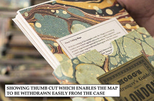
Old Folding Maps specialise in supplying original maps and reproductions of rarer antique maps - all dissected, laid onto 100% natural linen cloth and supplied in unique hand-made matching slip cases. This is a very special gift for a map-lover.
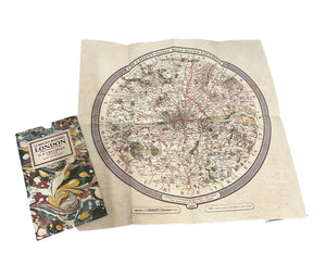
Cruchley's Twelve Miles Round London, taken from the original antique copper engraved map or plan published in circa 1826 by G.F.Cruchley Of 38 Ludgate Street. It extends from Southall in the west to Dagenham in the east and Waltham Abbey in the north to Croydon in the south. The principal parks and gentleman's seats or coloured in green. This map extends 12 miles from central London because this was half a days journey on your horse in 1826. It was reckoned that a rider could travel to London and back from anywhere within the area covered by this map in a morning.
George Frederick Cruchley (1796 - 1880) was a map publisher in the middle part of the 19th century, setting up his business in the early 1820's. His maps were clear and well engraved and he was very successful throughout his business career, finally selling his stock in 1877, three years before his death.
We offer free standard UK delivery on all orders over £50.
Please note: Orders placed after midday 19 December 2025 and until 4 January 2026 (inclusive) will be processed and despatched from the week beginning 5 January 2026.
Christmas delivery: Last recommended order date for UK orders is 12 December 2025. The last recommended order date for international orders is 17 November 2025.
Due to the EU Regulation 2023/988 (GPSR) we are currently unable to accept any orders for delivery to EU member countries, Switzerland and Northern Ireland. We apologise for any inconvenience caused.
Orders up to £30 are charged a flat fee of £4.95
Orders between £30.01 and £50 are charged a flat fee of £6.95.
Usual UK delivery timescale (excluding custom prints) is between 5 and 7 working days from the date of dispatch. Please allow up to 14 working days for delivery. For custom print delivery pricing and timescales see below. These timescales may vary especially when we have online sales and in the weeks before Christmas.
Delivery Worldwide
We can ship to selected countries worldwide.
For full details, including prices, click here.
Custom Prints
Your prints and frames will be handmade by King & McGaw at their Sussex workshop.
Unframed orders are shipped within 5 working days (normally shipped next day).
Framed orders are shipped within 20 working days.
Further information on delivery timescales for custom prints can be found here.
If you are not completely satisfied with your item you may return it within 28 days for a refund.
For further details on returns click here.
Unfortunately we cannot offer a refund on custom prints unless they are faulty or we have made a mistake. Custom prints are exempt as they are made to order.
Made In: United Kingdom
SKU: LON003
Old Folding Maps specialise in supplying original maps and reproductions of rarer antique maps - all dissected, laid onto 100% natural linen cloth and supplied in unique hand-made matching slip cases. This is a very special gift for a map-lover.
Cruchley's Twelve Miles Round London, taken from the original antique copper engraved map or plan published in circa 1826 by G.F.Cruchley Of 38 Ludgate Street. It extends from Southall in the west to Dagenham in the east and Waltham Abbey in the north to Croydon in the south. The principal parks and gentleman's seats or coloured in green. This map extends 12 miles from central London because this was half a days journey on your horse in 1826. It was reckoned that a rider could travel to London and back from anywhere within the area covered by this map in a morning.
George Frederick Cruchley (1796 - 1880) was a map publisher in the middle part of the 19th century, setting up his business in the early 1820's. His maps were clear and well engraved and he was very successful throughout his business career, finally selling his stock in 1877, three years before his death.
We offer free standard UK delivery on all orders over £50.
Please note: Orders placed after midday 19 December 2025 and until 4 January 2026 (inclusive) will be processed and despatched from the week beginning 5 January 2026.
Christmas delivery: Last recommended order date for UK orders is 12 December 2025. The last recommended order date for international orders is 17 November 2025.
Due to the EU Regulation 2023/988 (GPSR) we are currently unable to accept any orders for delivery to EU member countries, Switzerland and Northern Ireland. We apologise for any inconvenience caused.
Orders up to £30 are charged a flat fee of £4.95
Orders between £30.01 and £50 are charged a flat fee of £6.95.
Usual UK delivery timescale (excluding custom prints) is between 5 and 7 working days from the date of dispatch. Please allow up to 14 working days for delivery. For custom print delivery pricing and timescales see below. These timescales may vary especially when we have online sales and in the weeks before Christmas.
Delivery Worldwide
We can ship to selected countries worldwide.
For full details, including prices, click here.
Custom Prints
Your prints and frames will be handmade by King & McGaw at their Sussex workshop.
Unframed orders are shipped within 5 working days (normally shipped next day).
Framed orders are shipped within 20 working days.
Further information on delivery timescales for custom prints can be found here.
If you are not completely satisfied with your item you may return it within 28 days for a refund.
For further details on returns click here.
Unfortunately we cannot offer a refund on custom prints unless they are faulty or we have made a mistake. Custom prints are exempt as they are made to order.


